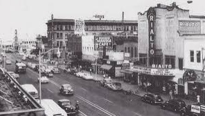
Phoenix, Arizona, is the capital and most populous city of the state of Arizona. The history of Phoenix dates back to ancient times, with evidence of human habitation in the area dating back to the prehistoric Hohokam people.
The Hohokam people built a complex network of canals to irrigate the land, which allowed them to farm and support a large population. The Hohokam civilization thrived in the area for hundreds of years before mysteriously disappearing around 1450 AD.
In the late 1700s, Spanish explorers and Catholic priests arrived in the area and established missions and forts. In the 1800s, American settlers began to arrive in the area and began to farm and raise cattle.
Phoenix was officially founded in 1867 by Jack Swilling, a Confederate veteran who was prospecting for gold and silver in the area. He realized that the Hohokam canals could be used for irrigation and began to farm the land. The town of Phoenix was officially established in 1868.
During the latter half of the 1800s, Phoenix grew as a center of agriculture, with cotton and citrus becoming the major crops. In the early 1900s, Phoenix began to develop as a city, with the construction of roads, schools, and businesses.
In the 1920s, the city experienced a population boom due to the construction of the Theodore Roosevelt Dam and the Coolidge Dam, which created a reliable source of water for irrigation and development.
A historical image of Phoenix

