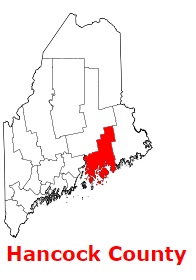
Hancock County is a coastal county in the eastern part of Maine. The population of Hancock County exceeds 56 thousand people. The county, established back in 1790 as Hancock County, Massachusetts, from part of Lincoln County, spans a total area of 2,351 square miles. The county seat of Hancock County is Ellsworth. The county is named after John Hancock (1737-1793), the Founding Father and president of the convention that produced the United States Declaration of Independence. This map shows the borders of Hancock County as well as neighboring counties,
including major highways and natural objecsts as of 2024.
Zoom in or out of the map using the plus/minus panel. Move the center of this map by dragging it.
Also check out the satellite map of Hancock County.
Please share the map of Hancock County with your friends:
The borders of Hancock County over the map of Maine
Explore some more counties of Maine:
This online map of Hancock County, Maine is provided by Bing Maps.
Please add a bookmark and share the page with your friends!