The exact coordinates of Patterson Louisiana for your GPS track:
Latitude 29.693571 North, Longitude 91.302414 West.
Share on Facebook
Share on WhatsApp
Share on Telegram
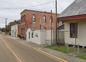
An image of Patterson

More city maps of Louisiana:
- Map of Monroe
Monroe is a city in northern Louisiana with a population of over 48 thousand people. It stands on ... - Map of Bossier City
Bossier City, Louisiana is a large eastern suburb of Shreveport with 68 thousand inhabitants. It w... - Map of Central
Central, Louisiana is a shining city located in East Baton Rouge Parish. Incorporated in April 200... - Map of Chalmette
Chalmette, Louisiana is a nice CDP, a suburb of New Orleans and the seat of St. Bernard Parish. To... - Map of Bayou Cane
Bayou Cane, Louisiana is a wonderful CDP standing near Houma, in Terrebonne Parish. The population... - Map of Opelousas
Opelousas, Louisiana is a wonderful city situated in St. Landry Parish. It stands in the central p... - Map of River Ridge
River Ridge is a suburban community located in Jefferson Parish, Louisiana. It stands in the south... - Map of Gonzales
Gonzales, Louisiana is a charming city found in Ascension Parish. It stands in the southeastern pa... - Map of Woodmere
Woodmere, Louisiana is a charming CDP found in Jefferson Parish. It stands near the city of Harvey... - Map of Raceland
Raceland is a community located in Lafourche Parish in southeastern Louisiana. It is known for its... - Map of Belle Chasse
Belle Chasse is an adorable suburban community located in Plaquemines Parish, in the southeastern ... - Map of Fort Polk South
Fort Polk South is a census-designated place located near Fort Polk, an active military installati... - Map of Harahan
Harahan, Louisiana is a shining city situated in Jefferson Parish. It stands on the east bank of t... - Map of Westwego
Westwego is a city in Jefferson Parish, Louisiana. Westwego stands on the west bank of the Mississ... - Map of Bridge City
Bridge City, Louisiana is a census-designated place located in Jefferson Parish. It stands on the ... - Map of Meraux
Meraux is a wonderful community and a CDP located in St. Bernard Parish, Louisiana. It is part of ... - Map of Larose
Larose is a pleasant community and a CDP located in Lafourche Parish, Louisiana. It sits in the so...
Full list of Louisiana maps
This online map of Patterson, Louisiana is provided by Bing Maps. Please add a bookmark and share the page with your friends!
