The exact coordinates of Bel Air Maryland for your GPS track:
Latitude 39.535473 North, Longitude 76.348259 West.
Share on Facebook
Share on WhatsApp
Share on Telegram
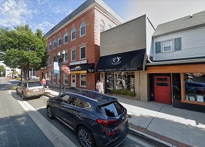
An image of Bel Air

More city maps of Maryland:
- Map of Gaithersburg
Gaithersburg AKA Gburg is a beautiful city in central Maryland with 68 thousand residents. It was ... - Map of Waldorf
Waldorf, Maryland is a large unincorporated city (CDP) in in Charles County. Its population exceed... - Map of Bowie
Bowie, Maryland (Incorporated 1882) is a city in Prince George's County, home to 58 thousand resid... - Map of Severn
Severn, Maryland is a CDP in Anne Arundel County with 49 thousand residents. It is located 10 mile... - Map of Wheaton
Wheaton, Maryland is a CDP with 52 thousand residents, located in Montgomery County. It is a north... - Map of Woodlawn
Woodlawn, Maryland is a beautiful suburban CDP of Baltimore, located in Baltimore County. Woodlawn... - Map of Annapolis
Annapolis is the capital city of Maryland, located on the coasts of Chesapeake Bay, in Anne Arunde... - Map of Olney
Olney, Maryland is a CDP situated about 18 miles north to Washington, DC, in Montgomery County. Ol... - Map of Salisbury
The city of Salisbury, Maryland is the county seat of Wicomico County. Salisbury is populated thes... - Map of Eldersburg
Eldersburg, Maryland is a nice CDP located 30 miles morthwest of Baltimore, in Carroll County. Fou... - Map of Laurel
Laurel, Maryland is a wonderful city situated in Prince George's County. Incorporated in 1870, tod... - Map of South Laurel
South Laurel, Maryland is a pleasant CDP found midway between Baltimore and Washington, DC, in Pri... - Map of Suitland
Suitland, Maryland is a charming CDP found near Washington DC, in Prince George's County. The popu... - Map of Arnold
Arnold, Maryland is a coastal CDP located 22 miles south of Baltimore, in Anne Arundel County. Tod... - Map of Elkridge
Elkridge, Maryland is a beautiful CDP situated in Howard County. Today Elkridge is populated by 22... - Map of Langley Park
Langley Park, Maryland is a shining unincorporated community located in Prince George's County. It... - Map of Cumberland
Cumberland is a city located in Allegany County, Maryland. It stands in the western part of the st...
Full list of Maryland maps
This online map of Bel Air, Maryland is provided by Bing Maps. Please add a bookmark and share the page with your friends!
