Where is The front line in Ukraine War on the map? Exact location of The front line in Ukraine War and coordinates.

The frontline in Russo-Ukrainian war stretches over 700 miles in East and South Ukraine. The lines are moving from day to day, so here is the actual frontline as of October 4, 2002. The line crosses Kharkiv region, then goes south to Donetsk Oblast, then passes through Zaporizhzhya region and finally ends near Kherson, which is still under Russian occupation.

The front line in Ukraine War today?

Here you can see an interactive Open Street map which shows the exact location of The front line in Ukraine War. To zoom in or out and see the surrounding area, use the buttons shown on the map. To see the surrounding objects, drag the map with your mouse or finger.
Also check out The front line in Ukraine War on satellite map.
Exact coordinates of The front line in Ukraine War: Latitude: 49.000763 North, Longitude: 37.911697 East.


Please share the link with friends and neighbors:
Share on Facebook
Share on WhatsApp
Share on Telegram

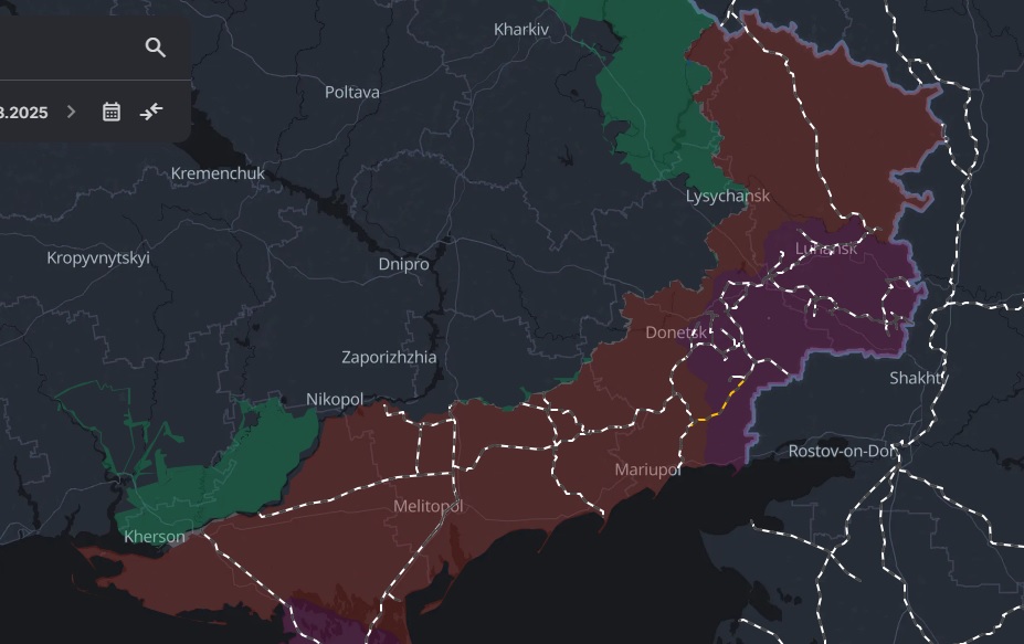
The front line in Ukraine War is listed in: Military objects

Image of The front line in Ukraine War:

The front line in Ukraine War photo


Check out some more famous and interesting places on our planet:

This online map of The front line in Ukraine War is provided by OpenStreetMap.
Please add a bookmark and share the page with your friends!


© 2024 City maps and famous places