The exact coordinates of Huntsville Alabama for your GPS track:
Latitude 34.731579 North, Longitude 86.588341 West.
Please share the link with friends and neighbors:
Share on Facebook
Share on WhatsApp
Share on Telegram
Share on Facebook
Share on WhatsApp
Share on Telegram
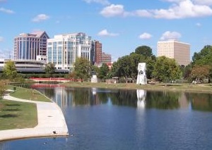
An image of Huntsville
More city maps of Alabama:
- Map of Tuscaloosa
Tuscaloosa is the fifth-largest city in Alabama with population of some 95 thousand people. Tuscal... - Map of Dothan
Dothan, Alabama is a small city located on the border between Alabama and Florida. The population ... - Map of Gadsden
Gadsden, Alabama (incorporated in 1867) is the county seat of Etowah County. The population of Gad... - Map of Homewood
Homewood, Alabama is a charming city found in Jefferson County. The population of Homewood exceeds... - Map of Oxford
Oxford, Alabama is a lovely city located mainly in Calhoun County. Incorporated, in 1852, today Ox... - Map of Cullman
Cullman is a city located in Cullman County, Alabama. It stands about 50 miles north of Birmingham... - Map of Calera
Calera, Alabama is a city located in Shelby County. It stands about 30 miles south of Birmingham a... - Map of Scottsboro
Scottsboro, Alabama is a city in Jackson County. It is situated in the northeastern part of the st... - Map of Chelsea
Chelsea, Alabama is a lovely city located in Shelby County. It stands in the central part of the s... - Map of Moody
Moody, Alabama is a shining city located in St. Clair County, about 20 miles east of Birmingham. M... - Map of Leeds
Leeds, Alabama is a city located in Jefferson and St. Clair Counties. It stands in the central par... - Map of Fairfield
Fairfield, Alabama is a wonderful city located in Jefferson County, in the central part of the sta... - Map of Meadowbrook
Meadowbrook, Alabama is a wonderful unincorporated community in Shelby County. It's located south ... - Map of Clanton
Clanton is an adorable city located in the central part of Alabama. It is the county seat of Chilt... - Map of Orange Beach
Orange Beach is a city located in Baldwin County, Alabama. It stands along the Gulf of Mexico in t... - Map of Montevallo
Montevallo, Alabama is a lovely city located in Shelby County. It is known for its historic charm,... - Map of Pinson
Pinson, Alabama is a lovely city located in Jefferson County. It sits in north-central Alabama, j...
Distances from Huntsville, Alabama:
- Distance between Huntsville and Tuscaloosa
- Distance between Huntsville and Dothan
- Distance between Huntsville and Gadsden
- Distance between Huntsville and Homewood
- Distance between Huntsville and Oxford
- Distance between Huntsville and Cullman
- Distance between Huntsville and Calera
- Distance between Huntsville and Scottsboro
- Distance between Huntsville and Chelsea
- Distance between Huntsville and Moody
- Distance between Huntsville and Leeds
- Distance between Huntsville and Fairfield
- Distance between Huntsville and Meadowbrook
- Distance between Huntsville and Clanton
- Distance between Huntsville and Orange Beach
- Distance between Huntsville and Montevallo
- Distance between Huntsville and Pinson
Full list of Alabama maps
This online map of Huntsville, Alabama is provided by Bing Maps. Please add a bookmark and share the page with your friends!