St. Clair County on the map of Alabama 2025. Cities, roads, borders and directions in St. Clair County of Alabama.
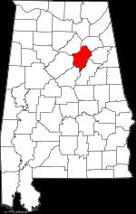
USA / Alabama / St. Clair CountySt. Clair County is situated in the northern region of Alabama. This wonderful county is named after Arthur St. Clair (1736-1818), President of Continental Congress. The area of St. Clair County is about 631.90 square miles. This county, created in 1818, is populated today by 93 thousand residents. Ashville and Pell City is the county seat of St. Clair County. This map shows the borders of St. Clair County as well as neighboring counties, including major highways and natural objecsts as of 2025. Zoom in or out of the map using the plus/minus panel. Move the center of this map by dragging it. Also check out the satellite map of St. Clair County.
The borders of St. Clair County over the map of Alabama
Explore some more counties of Alabama:
- Winston County
- Wilcox County
- Washington County
- Walker County
- Tuscaloosa County
- Tallapoosa County
- Talladega County
- Sumter County
- Shelby County
- Russell County
- Randolph County
- Pike County
- Pickens County
- Perry County
- Morgan County
- Montgomery County
- Monroe County
- Mobile County
- Marshall County
- Marion County
Full list of Alabama maps
This online map of St. Clair County, Alabama is provided by Bing Maps. Please add a bookmark and share the page with your friends!
© 2025 City maps and famous places