The exact coordinates of Heber Springs Arkansas for your GPS track:
Latitude 35.491558 North, Longitude 92.031441 West.
Please share the link with friends and neighbors:
Share on Facebook
Share on WhatsApp
Share on Telegram
Share on Facebook
Share on WhatsApp
Share on Telegram
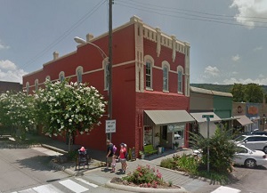
An image of Heber Springs
More city maps of Arkansas:
- Map of Rogers
Rogers, incorporated 1881, is a fast growing city in Northwest Arkansas. It is located in the cent... - Map of North Little Rock
North Little Rock, Arkansas is a city located, as its name suggests, on the northern edge of Littl... - Map of Benton
Benton, Arkansas is a wonderful city and the county seat of Saline County. Established in 1837, t... - Map of Paragould
Paragould, Arkansas is a shining city and the county seat of Greene County. Founded in in 1882, Pa... - Map of West Memphis
West Memphis, Arkansas is a hilarious city, a suburb of Memphis, Tennessee, situated in Crittenden... - Map of Wynne
Wynne is a city located in Cross County, Arkansas. It is situated in the eastern part of the state... - Map of El Dorado
El Dorado is a city located in the southern region of Arkansas. It is the county seat of Union Cou... - Map of Blytheville
Blytheville is a city located in the northeastern region of Arkansas. It is part of Mississippi Co... - Map of Batesville
Batesville is a city located in the north-central region of Arkansas. It is the county seat of Ind... - Map of Helena-West Helena
Helena-West Helena is a beautiful city located in eastern Arkansas. It stands along the Mississipp... - Map of Stuttgart
Stuttgart is an adorable city located in southeastern Arkansas. It is the county seat of Arkansas ... - Map of East End
East End, Arkansas is an adorable unincorporated community located in Saline County. It stands in ... - Map of Berryville
Berryville, Arkansas is a lovely city situated in Carroll County. It stands in the northwestern pa... - Map of Sheridan
Sheridan, Arkansas is a beautiful city that serves as the county seat of Grant County. It stands i...
Distances from Heber Springs, Arkansas:
- Distance between Heber Springs and Rogers
- Distance between Heber Springs and North Little Rock
- Distance between Heber Springs and Benton
- Distance between Heber Springs and Paragould
- Distance between Heber Springs and West Memphis
- Distance between Heber Springs and Wynne
- Distance between Heber Springs and El Dorado
- Distance between Heber Springs and Blytheville
- Distance between Heber Springs and Batesville
- Distance between Heber Springs and Helena-West Helena
- Distance between Heber Springs and Stuttgart
- Distance between Heber Springs and East End
- Distance between Heber Springs and Berryville
- Distance between Heber Springs and Sheridan
Full list of Arkansas maps
This online map of Heber Springs, Arkansas is provided by Bing Maps. Please add a bookmark and share the page with your friends!