Placer County on the map of California 2026. Cities, roads, borders and directions in Placer County of California.
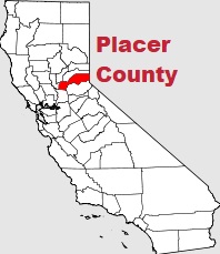
USA / California / Placer CountyPlacer County is a Charter county located in the eastern part of California. This wonderfuul county was established back in 1851. The county's total area is 1407 square miles. The county seat of Placer County is Auburn. The population of Placer County reaches 412 thousand residents. This map shows the borders of Placer County as well as neighboring counties, including major highways and natural objecsts as of 2026. Zoom in or out of the map using the plus/minus panel. Move the center of this map by dragging it. Also check out the satellite map of Placer County.
The borders of Placer County over the map of California
Explore some more counties of California:
- Yuba County
- Yolo County
- Tuolumne County
- Tulare County
- Trinity County
- Tehama County
- Sutter County
- Stanislaus County
- Sonoma County
- Solano County
- Siskiyou County
- Sierra County
- Shasta County
- Santa Cruz County
- Santa Barbara County
- San Mateo County
- San Luis Obispo County
- San Benito County
- Plumas County
- Nevada County
Full list of California maps
This online map of Placer County, California is provided by Bing Maps. Please add a bookmark and share the page with your friends!
© 2026 City maps and famous places