The exact coordinates of Fort Lauderdale Florida for your GPS track:
Latitude 26.122276 North, Longitude 80.140663 West.
Please share the link with friends and neighbors:
Share on Facebook
Share on WhatsApp
Share on Telegram
Share on Facebook
Share on WhatsApp
Share on Telegram
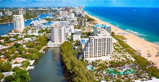
An image of Fort Lauderdale
More city maps of Florida:
- Map of St. Petersburg
St. Petersburg is a big city on Tampa Bay coast in western Florida with a population of 245 thousa... - Map of Plantation
Plantation, Florida (incorporated in 1953) is a resort city located near Fort Lauderdale. The popu... - Map of Miami Beach
Miami Beach, incorporated 1915, is a popular resort city located on a group of islands to the east... - Map of Riverview
Riverview Florida is a large CDP in the southeastern part of Tampa Bay area. Riverview is located ... - Map of Surfside
Surfside, Florida is a small coastal town in Miami-Dade county. Its population exceeds 5000 reside... - Map of Fort Myers
Fort Myers is a city in the southern part of Florida with some 86 thousand residents. It is the co... - Map of Homestead
Homestead, Florida is a large southern suburb of Miami located in Miami-Dade County. The populatio... - Map of The Villages
The Villages, Florida is a remarkable CDP located in Sumter County, about 55 miles southwest to Or... - Map of Delray Beach
Delray Beach, Florida is a nice coastal city situated near Boca Raton in Palm Beach County. Delray... - Map of Jupiter
Jupiter, Florida is a wonderful city situated in Palm Beach County. Jupiter is home to 65 thousand... - Map of North Miami
North Miami, Florida is a remarkable coastal city located in Miami-Dade County, about 9 miles nort... - Map of Sanford
The city of Sanford, Florida is the county seat of Seminole County. Sanford is located about 27 mi... - Map of Bonita Springs
Bonita Springs is an astonishing coastal city located in Lee County of Florida. Bonita Springs is ... - Map of Westchester
Westchester, Florida is a remarkable CDP located in Miami-Dade County, about 12 miles west to Miam... - Map of Country Club
Country Club, Florida is a nice CDP situated in Miami-Dade County, about 20 miles northwest to Mia... - Map of Four Corners
Four Corners AKA Citrus Ridge is an excellent CDP located in Lake County of Florida, about 25 mile... - Map of Altamonte Springs
Altamonte Springs, Florida is an excellent city, a northern suburb of Orlando, located in Seminole...
Distances from Fort Lauderdale, Florida:
- Distance between Fort Lauderdale and St. Petersburg
- Distance between Fort Lauderdale and Plantation
- Distance between Fort Lauderdale and Miami Beach
- Distance between Fort Lauderdale and Riverview
- Distance between Fort Lauderdale and Surfside
- Distance between Fort Lauderdale and Fort Myers
- Distance between Fort Lauderdale and Homestead
- Distance between Fort Lauderdale and The Villages
- Distance between Fort Lauderdale and Delray Beach
- Distance between Fort Lauderdale and Jupiter
- Distance between Fort Lauderdale and North Miami
- Distance between Fort Lauderdale and Sanford
- Distance between Fort Lauderdale and Bonita Springs
- Distance between Fort Lauderdale and Westchester
- Distance between Fort Lauderdale and Country Club
- Distance between Fort Lauderdale and Four Corners
- Distance between Fort Lauderdale and Altamonte Springs
Full list of Florida maps
This online map of Fort Lauderdale, Florida is provided by Bing Maps. Please add a bookmark and share the page with your friends!