Shelby County on the map of Iowa 2025. Cities, roads, borders and directions in Shelby County of Iowa.
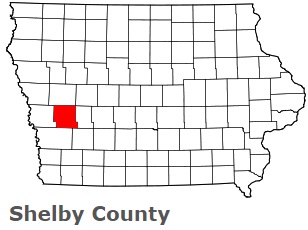
USA / Iowa / Shelby CountyShelby County is found in the western section of Iowa. This prominent county is named after Isaac Shelby, American Revolutionary War General, War of 1812. The population of Shelby County reaches 12 thousand people. The county, formed on Jan 15, 1851, covers an area of 591 square miles. The county seat of Shelby County is Harlan. This map shows the borders of Shelby County as well as neighboring counties, including major highways and natural objecsts as of 2025. Zoom in or out of the map using the plus/minus panel. Move the center of this map by dragging it. Also check out the satellite map of Shelby County.
The borders of Shelby County over the map of Iowa
Explore some more counties of Iowa:
- O'Brien County
- Wright County
- Worth County
- Woodbury County
- Winneshiek County
- Winnebago County
- Webster County
- Wayne County
- Washington County
- Warren County
- Wapello County
- Van Buren County
- Union County
- Taylor County
- Tama County
- Story County
- Sioux County
- Scott County
- Sac County
- Ringgold County
Full list of Iowa maps
This online map of Shelby County, Iowa is provided by Bing Maps. Please add a bookmark and share the page with your friends!
© 2025 City maps and famous places