The exact coordinates of Monmouth Illinois for your GPS track:
Latitude 40.912182 North, Longitude 90.648628 West.
Please share the link with friends and neighbors:
Share on Facebook
Share on WhatsApp
Share on Telegram
Share on Facebook
Share on WhatsApp
Share on Telegram
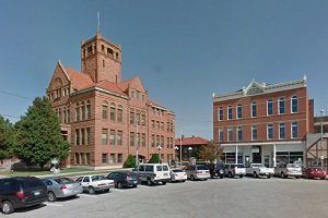
An image of Monmouth
More city maps of Illinois:
- Map of Springfield
Springfield is the Capital city of Illinois with population of around 114 thousand people.... - Map of Elgin
Elgin, Illinois (incorporated 1854) is a city located northwest to Chicago, along Fox River. With ... - Map of Waukegan
Waukegan is the ninth largest city in Illinois with 86 thousand residents. Located in the northeas... - Map of Decatur
Decatur is a beautiful city, serving as the county seat of Macon County, Illinois. The total popul... - Map of Oak Lawn
Oak Lawn, Illinois is a suburban village located about 15 miles southwest to downtown Chicago. Oak... - Map of Oak Park
Oak Park, Illinois is a wealthy village situated in Cook County, just about 9 miles west to downto... - Map of Lombard
Lombard, Illinois is an outstanding village located in DuPage County, about 21 miles west to downt... - Map of DeKalb
DeKalb, Illinois is a splendid city situated about 64 miles west to downtown Chicago, in DeKalb Co... - Map of Park Ridge
Park Ridge, Illinois is an impressive city located in Cook County, about 16 miles northwest to dow... - Map of Hanover Park
Hanover Park, Illinois is a quiet village situated about 33 miles northwest to downtown Chicago. T... - Map of Northbrook
Northbrook, Illinois is an impressive suburban village of Chicago, located in Cook County. Incorpo... - Map of Elk Grove Village
Elk Grove Village, Illinois is situated in Cook County, about 22 miles northwest to downtown Chica... - Map of North Chicago
North Chicago, Illinois is a city located on a beautiful coast of Lake Michigan, 40 miles north to... - Map of Danville
The city of Danville, Illinois is the county seat of Vermilion County. It is situated about 140 mi... - Map of New Lenox
New Lenox, Illinois is an attractive village located in Will County. Incorporated in 1946, New Len... - Map of Vernon Hills
Vernon Hills, Illinois (founded in 1851) is a stylish village found in Lake County, about 37 miles... - Map of West Chicago
West Chicago, Illinois is a suburban city of Chicago located in DuPage County. West Chicago is hom...
Full list of Illinois maps
This online map of Monmouth, Illinois is provided by Bing Maps. Please add a bookmark and share the page with your friends!