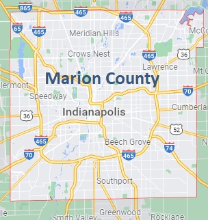
Marion County on the map of Indiana 2026. Cities, roads, borders and directions in Marion County of Indiana.
USA / Indiana / Marion CountyMarion County is the most populous county of Indiana, located around Indianapolis, its county seat. The total area of Marion County is about 403 square miles, and the population is one million residents. This map shows the borders of Marion County as well as neighboring counties, including major highways and natural objecsts as of 2026. Zoom in or out of the map using the plus/minus panel. Move the center of this map by dragging it. Also check out the satellite map of Marion County.
The borders of Marion County over the map of Indiana
Explore some more counties of Indiana:
- Whitley County
- White County
- Wells County
- Wayne County
- Washington County
- Warrick County
- Warren County
- Wabash County
- Vigo County
- Vermillion County
- Vanderburgh County
- Union County
- Tipton County
- Tippecanoe County
- Switzerland County
- Sullivan County
- Steuben County
- Starke County
- Spencer County
- Shelby County
Full list of Indiana maps
This online map of Marion County, Indiana is provided by Bing Maps. Please add a bookmark and share the page with your friends!
© 2026 City maps and famous places