Saline County on the map of Kansas 2026. Cities, roads, borders and directions in Saline County of Kansas.
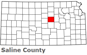
USA / Kansas / Saline CountySaline County is located in the central part of Kansas. This excellent county is named after Saline River, which flows through the county. The county seat of Saline County is Salina. The county's area is estimated at 720 square miles. Established in 1860, today Saline County is home to 54 thousand residents. This map shows the borders of Saline County as well as neighboring counties, including major highways and natural objecsts as of 2026. Zoom in or out of the map using the plus/minus panel. Move the center of this map by dragging it. Also check out the satellite map of Saline County.
The borders of Saline County over the map of Kansas
Explore some more counties of Kansas:
- Wyandotte County
- Woodson County
- Wilson County
- Wichita County
- Washington County
- Wallace County
- Wabaunsee County
- Trego County
- Thomas County
- Sumner County
- Stevens County
- Stanton County
- Stafford County
- Smith County
- Sherman County
- Sheridan County
- Shawnee County
- Seward County
- Sedgwick County
- Scott County
Full list of Kansas maps
This online map of Saline County, Kansas is provided by Bing Maps. Please add a bookmark and share the page with your friends!
© 2026 City maps and famous places