Allegany County on the map of Maryland 2025. Cities, roads, borders and directions in Allegany County of Maryland.
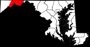
USA / Maryland / Allegany CountyAllegany County is a weakly populatied county in the northwestern part of Maryland. The county seat of Allegany County is Cumberland. The total area of the county is about 430 square miles. Established back in 1789, today Allegany County counts over 68 thousand inhabitants. This map shows the borders of Allegany County as well as neighboring counties, including major highways and natural objecsts as of 2025. Zoom in or out of the map using the plus/minus panel. Move the center of this map by dragging it. Also check out the satellite map of Allegany County.
The borders of Allegany County over the map of Maryland
Explore some more counties of Maryland:
- Worcester County
- Wicomico County
- Washington County
- Talbot County
- Somerset County
- Kent County
- Howard County
- Harford County
- Garrett County
- Frederick County
- Dorchester County
- Charles County
- Cecil County
- Carroll County
- Caroline County
- Calvert County
- Anne Arundel County
- Baltimore County
- Prince George's County
- Montgomery County
Full list of Maryland maps
This online map of Allegany County, Maryland is provided by Bing Maps. Please add a bookmark and share the page with your friends!
© 2025 City maps and famous places