The exact coordinates of Albert Lea Minnesota for your GPS track:
Latitude 43.647816 North, Longitude 93.368919 West.
Please share the link with friends and neighbors:
Share on Facebook
Share on WhatsApp
Share on Telegram
Share on Facebook
Share on WhatsApp
Share on Telegram
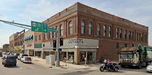
An image of Albert Lea
More city maps of Minnesota:
- Map of Minneapolis
Minneapolis is the largest city in the state of Minnesota, located in the eastern part of the stat... - Map of Woodbury
Woodbury is a city located on the eastern edge of Minneapolis metropolitan area. The population of... - Map of Coon Rapids
Coon Rapids, Minnesota is a lovely city found in Anoka County. The population of Coon Rapids excee... - Map of St. Louis Park
St. Louis Park, Minnesota is a fantastic city located about 7 miles west to downtown Minneapolis, ... - Map of Cottage Grove
Cottage Grove, Minnesota is a nice city located about 22 miles southeast of Minneapolis, in Washin... - Map of Fridley
Fridley, Minnesota is an attractive city located in Anoka County. Fridley is home to 30 thousand r... - Map of Chaska
Chaska, Minnesota is a wonderful city and the county seat of Carver County. Today Chaska is popula... - Map of Austin
Austin, Minnesota is a wonderful city, the county seat Mower County. Incorporated in 1856, today ... - Map of White Bear Lake
White Bear Lake, Minnesota is a lovely city located 19 miles northeast of Minneapolis, in Ramsey C... - Map of Golden Valley
Golden Valley, Minnesota is a shining city located in Hennepin County. Incorporated in 1886, Golde... - Map of New Hope
New Hope, Minnesota is a shining suburb of Minneapolis, located in Hennepin County. Incorporated i... - Map of South St. Paul
South St. Paul, Minnesota is a suburban city situated in Dakota County. Today South St. Paul is po... - Map of Hugo
Hugo, Minnesota is a charming city found in Washington County. It stands in the eastern part of th... - Map of Monticello
Monticello is a city located in Wright County, Minnesota. It stands in the central part of the sta... - Map of Sauk Rapids
Sauk Rapids, Minnesota is an adorable city situated in Benton County. It stands in the central par... - Map of Vadnais Heights
Vadnais Heights, Minnesota is a lovely city found in Ramsey County. It is a suburb of the Twin Cit... - Map of St. Peter
St. Peter, Minnesota is a shining city located in Nicollet County. It stands in the southern part ...
Full list of Minnesota maps
This online map of Albert Lea, Minnesota is provided by Bing Maps. Please add a bookmark and share the page with your friends!