St. Louis County on the map of Missouri 2026. Cities, roads, borders and directions in St. Louis County of Missouri.
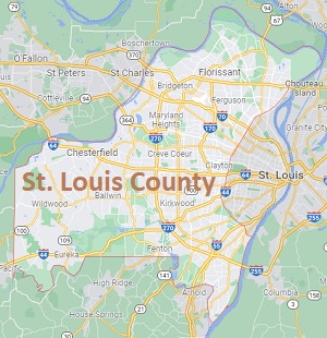
USA / Missouri / St. Louis CountySt. Louis County is the most populous county in Missouri. It is located on the western outskirts of St. Louis the city, but does not include it. The county seat here is Clayton and the largest city is Florissant. The total area of St. Louis County is 523 square miles. This map shows the borders of St. Louis County as well as neighboring counties, including major highways and natural objecsts as of 2026. Zoom in or out of the map using the plus/minus panel. Move the center of this map by dragging it. Also check out the satellite map of St. Louis County.
The borders of St. Louis County over the map of Missouri
Explore some more counties of Missouri:
- Wright County
- Worth County
- Webster County
- Wayne County
- Washington County
- Warren County
- Vernon County
- Texas County
- Taney County
- Sullivan County
- Stone County
- Stoddard County
- Shelby County
- Shannon County
- Scott County
- Scotland County
- Schuyler County
- Saline County
- Sainte Genevieve County
- Saint Francois County
Full list of Missouri maps
This online map of St. Louis County, Missouri is provided by Bing Maps. Please add a bookmark and share the page with your friends!
© 2026 City maps and famous places