Charlotte, North Carolina is the largest city in the state and the county seat of Mecklenburg County. The area was originally inhabited by the Catawba, Waxhaw and other indigenous peoples. The city of Charlotte was founded in 1768 by European settlers, and it quickly became a center for trade and commerce.
In the early days, the city's economy was largely based on agriculture, trade and military. Charlotte quickly developed into a major transportation hub, with the completion of the first railroads in the state and the construction of the first gold mint in the United States.
During the late 19th century and early 20th century, Charlotte continued to grow and diversify, with the construction of new buildings, infrastructure and industry. The city became a major center for the textile and banking industry.
In recent years, Charlotte has been working on redevelopment and revitalization, with a focus on tourism, cultural and art scene, and other initiatives to attract business and residents. The city also has a strong healthcare and education industry. Charlotte is also known for its rich history and cultural heritage, reflected in the many historic sites and landmarks in the area, such as the Levine Museum of the New South and the Mint Museum.
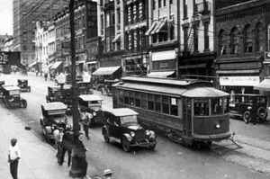
A historical image of Charlotte
In the early days, the city's economy was largely based on agriculture, trade and military. Charlotte quickly developed into a major transportation hub, with the completion of the first railroads in the state and the construction of the first gold mint in the United States.
During the late 19th century and early 20th century, Charlotte continued to grow and diversify, with the construction of new buildings, infrastructure and industry. The city became a major center for the textile and banking industry.
In recent years, Charlotte has been working on redevelopment and revitalization, with a focus on tourism, cultural and art scene, and other initiatives to attract business and residents. The city also has a strong healthcare and education industry. Charlotte is also known for its rich history and cultural heritage, reflected in the many historic sites and landmarks in the area, such as the Levine Museum of the New South and the Mint Museum.
A historical image of Charlotte