The exact coordinates of Waxahachie Texas for your GPS track:
Latitude 32.386028 North, Longitude 96.848152 West.
Please share the link with friends and neighbors:
Share on Facebook
Share on WhatsApp
Share on Telegram
Share on Facebook
Share on WhatsApp
Share on Telegram
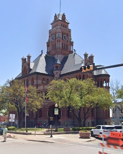
An image of Waxahachie
More city maps of Texas:
- Map of Amarillo
Amarillo is a city in northern Texas with over 200 thousand inhabitants. The city is nicknamed "Th... - Map of Mesquite
Mesquite is a city in Texas, an eastern suburb of Dallas. The population of Mesquite is about 140 ... - Map of McAllen
McAllen is a city on the southern tip of Texas, standing on the northern bank of Rio Grande, right... - Map of Richardson
Richardson, Texas is a large and wealthy suburb of Dallas with 108 thousand inhabitants.... - Map of Wichita Falls
Wichita Falls is a city in northern Texas with 104 thousand inhabitants. The city was founded in 1... - Map of The Woodlands
The Woodlands, Texas is a CDP located about 30 miles north to downtown Houston. This Special-purpo... - Map of New Braunfels
New Braunfels is a city in central Texas, located between Austin and San Antonio. The city was est... - Map of Atascocita
Atascocita, Texas is a large suburb of Houston with more than 80 thousand residents. It is a CDP l... - Map of San Marcos
San Marcos is a council-manager city in central Texas with 67 thousand residents. It is the county... - Map of Rowlett
Rowlett, Texas is a suburb of Dallas with 65 thousand residents. It stands on Lake Ray Hubbard.... - Map of Wylie
Wylie, Texas is a prominent city situated in Collin County, only 27 miles northeast to downtown Da... - Map of Grapevine
Grapevine, Texas is a breathtaking city situated near DFW airport, in Tarrant County. Grapevine is... - Map of Haltom City
Haltom City, Texas is a beautiful city located near Fort Worth, in Tarrant County. Haltom City is ... - Map of Lancaster
Lancaster, Texas is an charming suburban city of Dallas located in Dallas County. Lancaster is hom... - Map of Midlothian
Midlothian, Texas is a suburban city situated about 25 miles southwest to Dallas, in Ellis County.... - Map of La Porte
La Porte, Texas is a beautiful coastal city located near Houston, in Harris County. La Porte is po... - Map of Weatherford
Weatherford, Texas is the county seat of Parker County. Weatherford is populated these days by 34 ...
Distances from Waxahachie, Texas:
- Distance between Waxahachie and Amarillo
- Distance between Waxahachie and Mesquite
- Distance between Waxahachie and McAllen
- Distance between Waxahachie and Richardson
- Distance between Waxahachie and Wichita Falls
- Distance between Waxahachie and The Woodlands
- Distance between Waxahachie and New Braunfels
- Distance between Waxahachie and Atascocita
- Distance between Waxahachie and San Marcos
- Distance between Waxahachie and Rowlett
- Distance between Waxahachie and Wylie
- Distance between Waxahachie and Grapevine
- Distance between Waxahachie and Haltom City
- Distance between Waxahachie and Lancaster
- Distance between Waxahachie and Midlothian
- Distance between Waxahachie and La Porte
- Distance between Waxahachie and Weatherford
Full list of Texas maps
This online map of Waxahachie, Texas is provided by Bing Maps. Please add a bookmark and share the page with your friends!