Please share the link with friends and neighbors:
Share on Facebook
Share on WhatsApp
Share on Telegram
Share on Facebook
Share on WhatsApp
Share on Telegram
Hartsfield-Jackson Atlanta Airport is listed in:
Cool facts and FAQ about Hartsfield-Jackson Atlanta Airport:
Why is Hartsfield-Jackson considered the busiest airport in the world?How many terminals does Hartsfield-Jackson Atlanta Airport have?
What amenities and services are available at ATL?
How do passengers get to and from the airport?
What airlines use Hartsfield-Jackson as a hub?
What should travelers know about connecting flights at ATL?
Cool facts about Hartsfield-Jackson Atlanta Airport
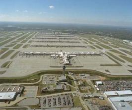
Image of Hartsfield-Jackson Atlanta Airport:
Check out some more famous and interesting places on our planet:
- Toronto Pearson Airport
- Richmond International Airport
- Memphis International Airport
- Charleston International Airport
- Buffalo Niagara International Airport
- Omaha Eppley Airfield
- Albuquerque International Sunport
- Anchorage International Airport
- Ontario International Airport
- Hollywood Burbank Airport
- Bradley International Airport
- General Mitchell International Airport
- Palm Beach International Airport
- Jacksonville International Airport
- Kahului Airport
- John Glenn Columbus International Airport
- Cincinnati/Northern Kentucky International Airport
- Luis Munoz Marin International Airport
- Pittsburgh International Airport
- Indianapolis International Airport
This online map of Hartsfield-Jackson Atlanta Airport is provided by OpenStreetMap.
Please add a bookmark and share the page with your friends!