Please share the link with friends and neighbors:
Share on Facebook
Share on WhatsApp
Share on Telegram
Share on Facebook
Share on WhatsApp
Share on Telegram
SoFi Stadium is listed in:
Cool facts and FAQ about SoFi Stadium:
What is SoFi Stadium?When did SoFi Stadium open?
What is the seating capacity of SoFi Stadium?
What amenities does SoFi Stadium offer?
What events are held at SoFi Stadium?
Cool facts about SoFi Stadium
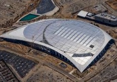
Image of SoFi Stadium:
Check out some more famous and interesting places on our planet:
- Giuseppe Dal Ben Arena
- Cortina Sliding Centre
- South Tyrol Arena
- Tofane Alpine Skiing Centre
- Cortina Curling Olympic Stadium
- Arena Santa Giulia
- Unipol Forum
- San Siro Stadium
- Legacy Arena
- PayPal Park
- Dick's Sporting Goods Park
- Children's Mercy Park
- Delaware Stadium
- Fargodome
- Ratliff Stadium
- Allianz Field
- Dana J Dykhouse Stadium
- Memorial Stadium at Bakersfield College
- Historic Crew Stadium
- Wailuku War Memorial Stadium
This online map of SoFi Stadium is provided by OpenStreetMap.
Please add a bookmark and share the page with your friends!