Please share the link with friends and neighbors:
Share on Facebook
Share on WhatsApp
Share on Telegram
Share on Facebook
Share on WhatsApp
Share on Telegram
Manneken Pis is listed in:
Cool facts and FAQ about Manneken Pis:
What is Manneken Pis?Why is Manneken Pis famous?
What are the legends behind Manneken Pis?
Does Manneken Pis have costumes?
Is Manneken Pis only in Brussels?
Cool facts about Manneken Pis
What is Manneken Pis?
Why is Manneken Pis famous?
What are the legends behind Manneken Pis?
Does Manneken Pis have costumes?
Is Manneken Pis only in Brussels?
Cool facts about Manneken Pis
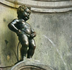
Image of Manneken Pis:
Check out some more famous and interesting places on our planet:
- The Statue of Unity
- Cloud Gate
- Spring Temple Buddha
- The Keeper of the Plains
- Christ the Redeemer
- The Statue of Liberty
This online map of Manneken Pis is provided by OpenStreetMap.
Please add a bookmark and share the page with your friends!