Please share the link with friends and neighbors:
Share on Facebook
Share on WhatsApp
Share on Telegram
Share on Facebook
Share on WhatsApp
Share on Telegram
Stade Roland Garros is listed in:
Cool facts and FAQ about Stade Roland Garros:
What is the French Open and why is it so special?When is the French Open played each year?
Why is playing on clay such a big deal at the French Open?
Who has won the most French Open titles?
Can regular fans visit Roland Garros outside of the tournament?
How do I get tickets to the French Open?
What makes the French Open different from other Grand Slams?
Cool facts about French Open
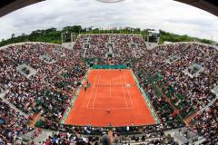
Image of Stade Roland Garros:
Check out some more famous and interesting places on our planet:
- Legacy Arena
- PayPal Park
- Dick's Sporting Goods Park
- Children's Mercy Park
- Delaware Stadium
- Fargodome
- Ratliff Stadium
- Allianz Field
- Dana J Dykhouse Stadium
- Memorial Stadium at Bakersfield College
- Historic Crew Stadium
- Wailuku War Memorial Stadium
- Brooks Stadium
- SeatGeek Stadium
- Kimbrough Memorial Stadium
- Mesquite Memorial Stadium
- Roy Kidd Stadium
- Riccardo Silva Stadium
- Brown Stadium
- America First Field
This online map of Stade Roland Garros is provided by OpenStreetMap.
Please add a bookmark and share the page with your friends!