Please share the link with friends and neighbors:
Share on Facebook
Share on WhatsApp
Share on Telegram
Share on Facebook
Share on WhatsApp
Share on Telegram
Stade de France is listed in:
Cool facts and FAQ about Stade de France:
What is Stade de France and where is it located?How do I get to Stade de France — best transport and directions?
What’s the capacity of Stade de France and what was the biggest crowd?
How do I buy Stade de France tickets and avoid scams?
What types of events happen at Stade de France and how often?
Are there stadium tours at Stade de France and what should I expect?
Cool facts about Stade de France
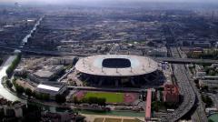
Image of Stade de France:
Check out some more famous and interesting places on our planet:
- Legacy Arena
- PayPal Park
- Dick's Sporting Goods Park
- Children's Mercy Park
- Delaware Stadium
- Fargodome
- Ratliff Stadium
- Allianz Field
- Dana J Dykhouse Stadium
- Memorial Stadium at Bakersfield College
- Historic Crew Stadium
- Wailuku War Memorial Stadium
- Brooks Stadium
- SeatGeek Stadium
- Kimbrough Memorial Stadium
- Mesquite Memorial Stadium
- Roy Kidd Stadium
- Riccardo Silva Stadium
- Brown Stadium
- America First Field
This online map of Stade de France is provided by OpenStreetMap.
Please add a bookmark and share the page with your friends!