Please share the link with friends and neighbors:
Share on Facebook
Share on WhatsApp
Share on Telegram
Share on Facebook
Share on WhatsApp
Share on Telegram
The Gherkin is listed in:
Cool facts and FAQ about The Gherkin:
What is The Gherkin and where is it located?When was The Gherkin completed?
What is inside The Gherkin?
Why is The Gherkin considered an architectural landmark?
Can the public visit The Gherkin?
Cool facts about The Gherkin
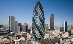
Image of The Gherkin:
Check out some more famous and interesting places on our planet:
- One Seaport
- 270 Park Avenue
- Ciel Dubai Marina
- Burj Binghatti
- The One Toronto
- Burj Azizi
- Shanghai Tower
- Tokyo Skytree
- Merdeka 118
- Comcast Technology Center
- Salesforce Tower
- Wilshire Grand Center
- Trump Tower
- The Mayo Hotel
- John Hancock Center
- U.S. Bank Tower
- One57
- Comcast Center
- Aon Center
- 432 Park Avenue
This online map of The Gherkin is provided by OpenStreetMap.
Please add a bookmark and share the page with your friends!