Boulder County on the map of Colorado 2026. Cities, roads, borders and directions in Boulder County of Colorado.
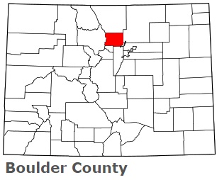
USA / Colorado / Boulder CountyBoulder County is located in the northern suburban part of Denver, Colorado. This special county is named after the abundance of granite boulders along Boulder Creek. The county seat of Boulder County is Boulder. The county's area is about 740 square miles. Established in 1861, today Boulder County is home to 330 thousand residents. This map shows the borders of Boulder County as well as neighboring counties, including major highways and natural objecsts as of 2026. Zoom in or out of the map using the plus/minus panel. Move the center of this map by dragging it. Also check out the satellite map of Boulder County.
The borders of Boulder County over the map of Colorado
Explore some more counties of Colorado:
- Yuma County
- Weld County
- Washington County
- Teller County
- Summit County
- Sedgwick County
- San Miguel County
- San Juan County
- Saguache County
- Routt County
- Rio Grande County
- Rio Blanco County
- Pueblo County
- Prowers County
- Pitkin County
- Phillips County
- Park County
- Ouray County
- Otero County
- Morgan County
Full list of Colorado maps
This online map of Boulder County, Colorado is provided by Bing Maps. Please add a bookmark and share the page with your friends!
© 2026 City maps and famous places