The exact coordinates of Makaha Hawaii for your GPS track:
Latitude 21.466616 North, Longitude 158.21286 West.
Please share the link with friends and neighbors:
Share on Facebook
Share on WhatsApp
Share on Telegram
Share on Facebook
Share on WhatsApp
Share on Telegram
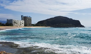
An image of Makaha
More city maps of Hawaii:
- Map of East Honolulu
East Honolulu is a CDP located on the eastern edge of Honolulu. With more than 50 thousand reside... - Map of Waipahu
Waipahu, Hawaii is a lovely community and census-designated place located in the Ewa District on t... - Map of Kapolei
Kapolei is a planned city and one of the fastest-growing communities located on the southwestern c... - Map of Wahiawa
Wahiawa is a town located on the island of Oahu in the state of Hawaii. It is situated in the cent... - Map of Royal Kunia
Royal Kunia, Hawaii is a wonderful residential community and a CDP located on the island of Oahu. ... - Map of Nanakuli
Nanakuli, Hawaii is a nice community and a CDP situated on the western coast of Oahu, the third-la...
Full list of Hawaii maps
This online map of Makaha, Hawaii is provided by Bing Maps. Please add a bookmark and share the page with your friends!