Owyhee County on the map of Idaho 2026. Cities, roads, borders and directions in Owyhee County of Idaho.
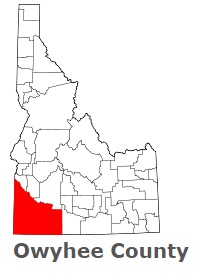
USA / Idaho / Owyhee CountyOwyhee County is found in the southwestern corner of Idaho. The county's name is an alternate spelling of Hawaii. Hawaiian fur trappers explored the area in 1819 and 1820. The population of Owyhee County exceeds 12 thousand people. The county, organized in 1863, spans an area of 7678 square miles. The county seat of Owyhee County is Murphy. This map shows the borders of Owyhee County as well as neighboring counties, including major highways and natural objecsts as of 2026. Zoom in or out of the map using the plus/minus panel. Move the center of this map by dragging it. Also check out the satellite map of Owyhee County.
The borders of Owyhee County over the map of Idaho
Explore some more counties of Idaho:
- Washington County
- Valley County
- Twin Falls County
- Teton County
- Shoshone County
- Power County
- Payette County
- Oneida County
- Nez Perce County
- Minidoka County
- Madison County
- Lincoln County
- Lewis County
- Lemhi County
- Latah County
- Kootenai County
- Jerome County
- Jefferson County
- Idaho County
- Gooding County
Full list of Idaho maps
This online map of Owyhee County, Idaho is provided by Bing Maps. Please add a bookmark and share the page with your friends!
© 2026 City maps and famous places