Tunica County on the map of Mississippi 2026. Cities, roads, borders and directions in Tunica County of Mississippi.
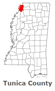
USA / Mississippi / Tunica CountyTunica County is found in the northwestern part of Mississippi. This amazing county is named after Tunica Native Americans. The overall population of Tunica County reaches 10 thousand people. The county, organized in 1836, covers an area of 455 square miles. The county seat of Tunica County is Tunica. This map shows the borders of Tunica County as well as neighboring counties, including major highways and natural objecsts as of 2026. Zoom in or out of the map using the plus/minus panel. Move the center of this map by dragging it. Also check out the satellite map of Tunica County.
The borders of Tunica County over the map of Mississippi
Explore some more counties of Mississippi:
- Yazoo County
- Yalobusha County
- Winston County
- Wilkinson County
- Webster County
- Wayne County
- Washington County
- Warren County
- Walthall County
- Union County
- Tishomingo County
- Tippah County
- Tate County
- Tallahatchie County
- Sunflower County
- Stone County
- Smith County
- Simpson County
- Sharkey County
- Scott County
Full list of Mississippi maps
This online map of Tunica County, Mississippi is provided by Bing Maps. Please add a bookmark and share the page with your friends!
© 2026 City maps and famous places