Burke County on the map of North Dakota 2025. Cities, roads, borders and directions in Burke County of North Dakota.
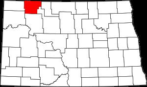
USA / North Dakota / Burke CountyBurke County is located in the northwestern part of North Dakota. This special county is named after John Burke, tenth Governor of North Dakota. The county seat of Burke County is Bowbells. The county's area is about 1104 square miles. Established in 1910, today Burke County is home to 2 thousand residents. This map shows the borders of Burke County as well as neighboring counties, including major highways and natural objecsts as of 2025. Zoom in or out of the map using the plus/minus panel. Move the center of this map by dragging it. Also check out the satellite map of Burke County.
The borders of Burke County over the map of North Dakota
Explore some more counties of North Dakota:
- Williams County
- Wells County
- Ward County
- Walsh County
- Traill County
- Towner County
- Stutsman County
- Steele County
- Stark County
- Slope County
- Sioux County
- Sheridan County
- Sargent County
- Rolette County
- Richland County
- Renville County
- Ransom County
- Ramsey County
- Pierce County
- Pembina County
Full list of North Dakota maps
This online map of Burke County, North Dakota is provided by Bing Maps. Please add a bookmark and share the page with your friends!
© 2025 City maps and famous places