Mercer County on the map of New Jersey 2026. Cities, roads, borders and directions in Mercer County of New Jersey.
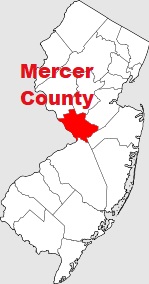
USA / New Jersey / Mercer CountyMercer County is an inland county situated in central New Jersey. This glorious county was set up in 1838. The county seat of Mercer County is Trenton, and the largest settlement is Hamilton Township. The population of Mercer County is about 386 thousand inhabitants. The overall area of the county is 226 square miles. This map shows the borders of Mercer County as well as neighboring counties, including major highways and natural objecsts as of 2026. Zoom in or out of the map using the plus/minus panel. Move the center of this map by dragging it. Also check out the satellite map of Mercer County.
The borders of Mercer County over the map of New Jersey
Explore some more counties of New Jersey:
- Warren County
- Union County
- Sussex County
- Somerset County
- Salem County
- Passaic County
- Ocean County
- Morris County
- Monmouth County
- Hunterdon County
- Hudson County
- Gloucester County
- Cumberland County
- Cape May County
- Camden County
- Burlington County
- Atlantic County
- Essex County
- Middlesex County
- Bergen County
Full list of New Jersey maps
This online map of Mercer County, New Jersey is provided by Bing Maps. Please add a bookmark and share the page with your friends!
© 2026 City maps and famous places