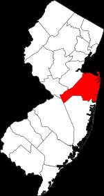
Monmouth County on the map of New Jersey 2025. Cities, roads, borders and directions in Monmouth County of New Jersey.
USA / New Jersey / Monmouth CountyMonmouth County is a coastal county in the central part of New Jersey. This important county was founded in 1683. The county is populated by 645 thousand people. The county seat of Monmouth County is Freehold Borough, and the largest city is Middletown Township. The overall area of the county is 472 square miles. This map shows the borders of Monmouth County as well as neighboring counties, including major highways and natural objecsts as of 2025. Zoom in or out of the map using the plus/minus panel. Move the center of this map by dragging it. Also check out the satellite map of Monmouth County.
The borders of Monmouth County over the map of New Jersey
Explore some more counties of New Jersey:
- Warren County
- Union County
- Sussex County
- Somerset County
- Salem County
- Passaic County
- Ocean County
- Morris County
- Mercer County
- Hunterdon County
- Hudson County
- Gloucester County
- Cumberland County
- Cape May County
- Camden County
- Burlington County
- Atlantic County
- Essex County
- Middlesex County
- Bergen County
Full list of New Jersey maps
This online map of Monmouth County, New Jersey is provided by Bing Maps. Please add a bookmark and share the page with your friends!
© 2025 City maps and famous places