Bucks County on the map of Pennsylvania 2025. Cities, roads, borders and directions in Bucks County of Pennsylvania.
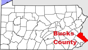
USA / Pennsylvania / Bucks CountyBucks County is located in Philadelphia suburban area of Pennsylvania. The county is named after The English county of Buckinghamshire. The county seat of Bucks County is Doylestown. The overall area of the county is about 622 square miles. Founded back in 1682, today Bucks County counts over 646 thousand inhabitants. This map shows the borders of Bucks County as well as neighboring counties, including major highways and natural objecsts as of 2025. Zoom in or out of the map using the plus/minus panel. Move the center of this map by dragging it. Also check out the satellite map of Bucks County.
The borders of Bucks County over the map of Pennsylvania
Explore some more counties of Pennsylvania:
- York County
- Wyoming County
- Westmoreland County
- Wayne County
- Washington County
- Warren County
- Venango County
- Union County
- Tioga County
- Susquehanna County
- Sullivan County
- Somerset County
- Snyder County
- Schuylkill County
- Potter County
- Pike County
- Perry County
- Northumberland County
- Northampton County
- Montour County
Full list of Pennsylvania maps
This online map of Bucks County, Pennsylvania is provided by Bing Maps. Please add a bookmark and share the page with your friends!
© 2025 City maps and famous places