Cumberland County on the map of Pennsylvania 2025. Cities, roads, borders and directions in Cumberland County of Pennsylvania.
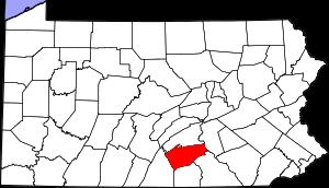
USA / Pennsylvania / Cumberland CountyCumberland County is placed in the southern section of Pennsylvania. The county is named after The historic English county of Cumberland. The population of Cumberland County exceeds 263 thousand people. The county, established back in 1750, spans a total area of about 551 square miles. The county seat of Cumberland County is Carlisle. This map shows the borders of Cumberland County as well as neighboring counties, including major highways and natural objecsts as of 2025. Zoom in or out of the map using the plus/minus panel. Move the center of this map by dragging it. Also check out the satellite map of Cumberland County.
The borders of Cumberland County over the map of Pennsylvania
Explore some more counties of Pennsylvania:
- York County
- Wyoming County
- Westmoreland County
- Wayne County
- Washington County
- Warren County
- Venango County
- Union County
- Tioga County
- Susquehanna County
- Sullivan County
- Somerset County
- Snyder County
- Schuylkill County
- Potter County
- Pike County
- Perry County
- Northumberland County
- Northampton County
- Montour County
Full list of Pennsylvania maps
This online map of Cumberland County, Pennsylvania is provided by Bing Maps. Please add a bookmark and share the page with your friends!
© 2025 City maps and famous places