Please share the link with friends and neighbors:
Share on Facebook
Share on WhatsApp
Share on Telegram
Share on Facebook
Share on WhatsApp
Share on Telegram
Mount Everest is listed in:
Cool facts and FAQ about Mount Everest:
What is Mount Everest?How high is Mount Everest?
Who first climbed Mount Everest?
What are the main climbing routes on Mount Everest?
What dangers exist when climbing Mount Everest?
What wildlife and ecosystems are found near Mount Everest?
What is the climate like on Mount Everest?
Cool facts about Mount Everest
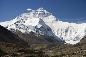
Image of Mount Everest:
Check out some more famous and interesting places on our planet:
- Stromboli volcano
- Genting Snow Park
- Cumbre Vieja
- Mount Lewotolo
- Nevado Mismi
- Mount Rainier
- Mount Elbrus
- Mount Carmel
- Matterhorn
- Mont Blanc
- Devils Tower
- Ben Nevis mountain
- Mount Etna
- Mount Fuji
This online map of Mount Everest is provided by OpenStreetMap.
Please add a bookmark and share the page with your friends!