Please share the link with friends and neighbors:
Share on Facebook
Share on WhatsApp
Share on Telegram
Share on Facebook
Share on WhatsApp
Share on Telegram
Fukushima Power Plant is listed in:
Cool facts and FAQ about Fukushima Power Plant:
What happened at the Fukushima Daiichi Power Plant?Is the area around the Fukushima plant still dangerous?
What are the main risks from radiation after Fukushima accident?
Can you visit the Fukushima Daiichi plant site today?
What’s being done to clean up and decommission Fukushima plant?
Are people living in Fukushima today healthy?
Was Fukushima as bad as Chernobyl?
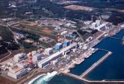
Image of Fukushima Power Plant:
Check out some more famous and interesting places on our planet:
- Fort Lesley J. McNair
- T4 Airbase
- ADX Florence
- The front line in Ukraine War
- RAF Northolt
- Chernobyl nuclear power plant
- Zaporizhzhia nuclear power plant
- Starbase Texas
- Scotland Yard
- Nellis Air Force Base
- Shayrat Air Base
- Guantanamo
- The Pentagon
- Pearl Harbor
- Area 51
This online map of Fukushima Power Plant is provided by OpenStreetMap.
Please add a bookmark and share the page with your friends!