Please share the link with friends and neighbors:
Share on Facebook
Share on WhatsApp
Share on Telegram
Share on Facebook
Share on WhatsApp
Share on Telegram
Yosemite National Park is listed in:
Cool facts and FAQ about Yosemite National Park:
What is Yosemite National Park famous for?When was Yosemite National Park established?
What are the most popular attractions in Yosemite?
What kind of wildlife can be found in Yosemite?
What is the best time to visit Yosemite National Park?
Can you camp inside Yosemite National Park?
How many visitors does Yosemite receive each year?
Cool facts about Yosemite Park
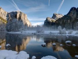
Image of Yosemite National Park:
Check out some more famous and interesting places on our planet:
- Joshua Tree National Park
- The Point State Park
- New Haven Green
- Fort Shantok Park
- Grand Park
- Genting Snow Park
- Oak Mountain State Park
- Sutter's Fort
- Morningside Park
- Battery Park
- Custer State Park
- High Line Park
- Badlands National Park
- Millennium Park
- Yellowstone National Park
- Hyde Park
This online map of Yosemite National Park is provided by OpenStreetMap.
Please add a bookmark and share the page with your friends!