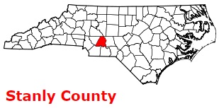
Stanly County on the map of North Carolina 2026. Cities, roads, borders and directions in Stanly County of North Carolina.
USA / North Carolina / Stanly CountyStanly County is located in Charlotte suburban region of North Carolina. The county is named after John Stanly (1774-1834), a United States Congressman and Speaker of the North Carolina House of Commons. The county seat of Stanly County is Albemarle. The county's area exceeds 404 square miles. Founded in 1841 from Montgomery County, today Stanly County counts over 63 thousand inhabitants. This map shows the borders of Stanly County as well as neighboring counties, including major highways and natural objecsts as of 2026. Zoom in or out of the map using the plus/minus panel. Move the center of this map by dragging it. Also check out the satellite map of Stanly County.
The borders of Stanly County over the map of North Carolina
Explore some more counties of North Carolina:
- Yancey County
- Yadkin County
- Wilson County
- Wilkes County
- Wayne County
- Watauga County
- Washington County
- Warren County
- Vance County
- Union County
- Tyrrell County
- Transylvania County
- Swain County
- Surry County
- Stokes County
- Scotland County
- Sampson County
- Rutherford County
- Rowan County
- Rockingham County
Full list of North Carolina maps
This online map of Stanly County, North Carolina is provided by Bing Maps. Please add a bookmark and share the page with your friends!
© 2026 City maps and famous places