Warren County on the map of North Carolina 2026. Cities, roads, borders and directions in Warren County of North Carolina.
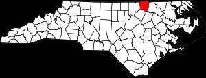
USA / North Carolina / Warren CountyWarren County is situated in the northern part of North Carolina. The county is named after Joseph Warren (1741-1775), a Patriot and volunteer private who was mortally wounded at the Battle of Bunker Hill. The area of Warren County is about 444 square miles. The county was founded in 1779 from Bute County, and it is populated today by 19 thousand residents. Warrenton is the county seat of Warren County. This map shows the borders of Warren County as well as neighboring counties, including major highways and natural objecsts as of 2026. Zoom in or out of the map using the plus/minus panel. Move the center of this map by dragging it. Also check out the satellite map of Warren County.
The borders of Warren County over the map of North Carolina
Explore some more counties of North Carolina:
- Yancey County
- Yadkin County
- Wilson County
- Wilkes County
- Wayne County
- Watauga County
- Washington County
- Vance County
- Union County
- Tyrrell County
- Transylvania County
- Swain County
- Surry County
- Stokes County
- Stanly County
- Scotland County
- Sampson County
- Rutherford County
- Rowan County
- Rockingham County
Full list of North Carolina maps
This online map of Warren County, North Carolina is provided by Bing Maps. Please add a bookmark and share the page with your friends!
© 2026 City maps and famous places