Please share the link with friends and neighbors:
Share on Facebook
Share on WhatsApp
Share on Telegram
Share on Facebook
Share on WhatsApp
Share on Telegram
Czech Republic is listed in:
Cool facts and FAQ about Czech Republic:
Do I need a visa to visit the Czech Republic?What is the Czech Republic famous for?
What’s the best time to visit the Czech Republic?
Can I drink beer everywhere in the Czech Republic?
Is Prague the only city worth visiting?
What language do people speak in the Czech Republic?
How safe is the Czech Republic for travelers?
What food should I try in the Czech Republic?
Can I explore castles and historic sites in the Czech Republic?
Cool facts about Czech Republic
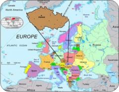
Image of Czech Republic:
Check out some more famous and interesting places on our planet:
- Sri Lanka
- Macao
- Ukraine
- Guinea-Bissau
- New Caledonia
- Guinea
- Ghana
- Georgia
- Gabon
- Ethiopia
- Djibouti
- Côte d'Ivoire
- Cuba
- Colombia
- Aruba
- Chad
- Cameroon
- Botswana
- Bosnia and Herzegovina
- Benin
This online map of Czech Republic is provided by OpenStreetMap.
Please add a bookmark and share the page with your friends!