Please share the link with friends and neighbors:
Share on Facebook
Share on WhatsApp
Share on Telegram
Share on Facebook
Share on WhatsApp
Share on Telegram
Finland is listed in:
Cool facts and FAQ about Finland:
Why is Finland called the happiest country in the world?What makes Finnish culture so different from other European countries?
How do Finns handle the long, dark winters?
Why are Finnish saunas such a big deal?
Is Finland really that expensive to visit?
What’s the deal in Finland with the midnight sun and polar night?
Why do Finns speak such good English?
How does Finland handle education so well?
Cool facts about Finland
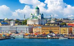
Image of Finland:
Check out some more famous and interesting places on our planet:
- Sri Lanka
- Macao
- Ukraine
- Guinea-Bissau
- New Caledonia
- Guinea
- Ghana
- Georgia
- Gabon
- Ethiopia
- Djibouti
- Côte d'Ivoire
- Cuba
- Colombia
- Aruba
- Chad
- Cameroon
- Botswana
- Bosnia and Herzegovina
- Benin
This online map of Finland is provided by OpenStreetMap.
Please add a bookmark and share the page with your friends!