Please share the link with friends and neighbors:
Share on Facebook
Share on WhatsApp
Share on Telegram
Share on Facebook
Share on WhatsApp
Share on Telegram
Palestine is listed in:
Cool facts and FAQ about Palestine:
What is Palestine today?What is the political status of Palestine?
Who are the Palestinians?
What languages are spoken in Palestine?
What are some key historical events related to Palestine?
What are the main economic activities in Palestine?
What cultural traditions are important in Palestine?
What challenges do Palestinians face today?
What is the role of the Palestinian Authority?
How does the international community view Palestine?
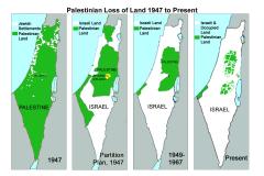
Image of Palestine:
Check out some more famous and interesting places on our planet:
- Bougainville
- New Brunswick
- Manitoba
- Alberta
- British Columbia
- Nova Scotia
- Ontario
- Grand Faw Port
- Hampshire
- Gloucestershire
- Essex
- East Sussex
- East Yorkshire
- Durham
- Dorset
- Devon
- Derbyshire
- Cumbria
- Cornwall
- Cheshire
This online map of Palestine is provided by OpenStreetMap.
Please add a bookmark and share the page with your friends!