Please share the link with friends and neighbors:
Share on Facebook
Share on WhatsApp
Share on Telegram
Share on Facebook
Share on WhatsApp
Share on Telegram
The Rhine is listed in:
Cool facts and FAQ about The Rhine:
Where does the Rhine River start and where does it end?Why is the Rhine so culturally and historically important?
What kind of lifestyle and leisure stuff can you enjoy along the Rhine?
How is the Rhine used today in terms of commerce and environment?
What should a visitor know about the scenic or travel highlights of the Rhine?
Are there any environmental or safety considerations to keep in mind about the Rhine?
Cool facts about the Rhine
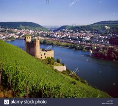
Image of The Rhine:
Check out some more famous and interesting places on our planet:
- Des Moines River
- Red River of the North
- Sabine River
- Little Missouri River
- Niobrara River
- Smoky Hill River
- Tanana River
- Sheyenne River
- Gila River
- St. Lawrence River
- Ouachita River
- Milk River
- North Platte River
- Yellowstone River
- Cumberland River
- Cimarron River
- Kuskokwim River
- James River
- White River
- Pecos River
This online map of The Rhine is provided by OpenStreetMap.
Please add a bookmark and share the page with your friends!