The exact coordinates of Sitka Alaska for your GPS track:
Latitude 57.053371 North, Longitude 135.333725 West.
Please share the link with friends and neighbors:
Share on Facebook
Share on WhatsApp
Share on Telegram
Share on Facebook
Share on WhatsApp
Share on Telegram
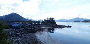
An image of Sitka
More city maps of Alaska:
- Map of College
College, Alaska is a nice CDP found in Fairbanks North Star Borough. It's commonly associated with... - Map of Gateway
Gateway, Alaska is a pleasant CDP found in Matanuska-Susitna Borough. It stands only about 38 mile... - Map of Kodiak
Kodiak is a city located on Kodiak Island, Alaska. It is the largest community on Kodiak Island an...
Full list of Alaska maps
This online map of Sitka, Alaska is provided by Bing Maps. Please add a bookmark and share the page with your friends!