Maps of Alaska cities online. Major cities and towns in Alaska
Main page /
USA / Alaska
 Alaska is the largest state in the United States, located in the northwest corner of North America. It is bordered by Canada to the east and Russia to the west across the Bering Strait. The state's capital is Juneau, and its largest city is Anchorage.
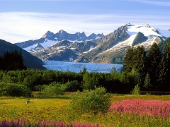
Alaska is known for its rugged, mountainous terrain and its abundant wildlife, including bears, moose, and caribou. The state is home to numerous national parks and protected areas, including Denali National Park, which is home to Mount Denali (formerly known as Mount McKinley), the highest peak in North America.
Alaska has a cold, subarctic climate, with long, harsh winters and short, cool summers. The state is home to a number of major industries, including oil and gas production, forestry, and fishing. It is also a popular destination for tourism, with visitors coming to experience its natural beauty and outdoor recreational opportunities.
These interactive maps contain detailed schemes of Alaska cities, including major sites and natural objecsts.
The cities are sorted alphabetically. You can search the maps to find any street or house. Click on the city name to view its detailed map.
List of counties in Alaska: