The borders of Kalawao County over the map of Hawaii
Explore some more counties of Hawaii:
Full list of Hawaii maps
This online map of Kalawao County, Hawaii is provided by Bing Maps. Please add a bookmark and share the page with your friends!
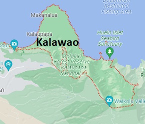
Kalawao County is situated on the Kalaupapa Peninsula on Molokaʻi island of Hawaii. This small county is named after the village of Kalawao on Molokai. The total area of Kalawao County is about 5 square miles. This county, created in 1905, is populated today by 82 residents. This map shows the borders of Kalawao County as well as neighboring counties, including major highways and natural objecsts as of 2024. Zoom in or out of the map using the plus/minus panel. Move the center of this map by dragging it. Also check out the satellite map of Kalawao County.
The borders of Kalawao County over the map of Hawaii
This online map of Kalawao County, Hawaii is provided by Bing Maps. Please add a bookmark and share the page with your friends!
© 2024 City maps and famous places