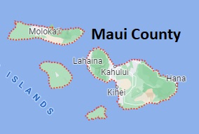
The borders of Maui County over the map of Hawaii
Explore some more counties of Hawaii:
Full list of Hawaii maps
This online map of Maui County, Hawaii is provided by Bing Maps. Please add a bookmark and share the page with your friends!
Maui County is found on Maui, Kahoʻolawe, Lānaʻi, Molokai (except the Kalaupapa Peninsula), and Molokini islands of Hawaii. This amazing county is named after Māui, a demigod from native mythology. The overall population of Maui County reaches 164 thousand people. The county, organized in 1905, covers an area of 1120 square miles. The county seat of Maui County is Wailuku. This map shows the borders of Maui County as well as neighboring counties, including major highways and natural objecsts as of 2024. Zoom in or out of the map using the plus/minus panel. Move the center of this map by dragging it. Also check out the satellite map of Maui County.
The borders of Maui County over the map of Hawaii
This online map of Maui County, Hawaii is provided by Bing Maps. Please add a bookmark and share the page with your friends!
© 2024 City maps and famous places