Beaufort County on the map of North Carolina 2026. Cities, roads, borders and directions in Beaufort County of North Carolina.
USA / North Carolina / Beaufort CountyBeaufort County is located in the coastal section of North Carolina. The county seat of Beaufort County is Washington. The county's area exceeds 959 square miles. Set up in 1712 from Bath County, today Beaufort County counts over 44 thousand inhabitants. The county is named after Henry Somerset, 2nd Duke of Beaufort, who in 1709 became one of the Lords Proprietor. This map shows the borders of Beaufort County as well as neighboring counties, including major highways and natural objecsts as of 2026. Zoom in or out of the map using the plus/minus panel. Move the center of this map by dragging it. Also check out the satellite map of Beaufort County.
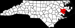
The borders of Beaufort County over the map of North Carolina
Explore some more counties of North Carolina:
- Yancey County
- Yadkin County
- Wilson County
- Wilkes County
- Wayne County
- Watauga County
- Washington County
- Warren County
- Vance County
- Union County
- Tyrrell County
- Transylvania County
- Swain County
- Surry County
- Stokes County
- Stanly County
- Scotland County
- Sampson County
- Rutherford County
- Rowan County
Full list of North Carolina maps
This online map of Beaufort County, North Carolina is provided by Bing Maps. Please add a bookmark and share the page with your friends!
© 2026 City maps and famous places