Hamilton County on the map of Ohio 2025. Cities, roads, borders and directions in Hamilton County of Ohio.
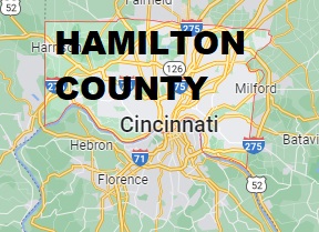
USA / Ohio / Hamilton CountyHamilton County is one of the most populous counties in Ohio with more than 830 thousand residents. Cincinnati is its county seat and the largest city as well. This map shows the borders of Hamilton County as well as neighboring counties, including major highways and natural objecsts as of 2025. Zoom in or out of the map using the plus/minus panel. Move the center of this map by dragging it. Also check out the satellite map of Hamilton County.
The borders of Hamilton County over the map of Ohio
Explore some more counties of Ohio:
- Wyandot County
- Wood County
- Williams County
- Wayne County
- Washington County
- Warren County
- Vinton County
- Van Wert County
- Ross County
- Union County
- Richland County
- Tuscarawas County
- Putnam County
- Trumbull County
- Preble County
- Summit County
- Portage County
- Stark County
- Pike County
- Shelby County
Full list of Ohio maps
This online map of Hamilton County, Ohio is provided by Bing Maps. Please add a bookmark and share the page with your friends!
© 2025 City maps and famous places