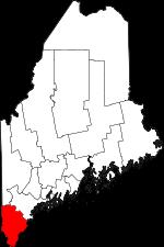
York County is the southernmost county in Maine. The county seat of York County is Alfred. The overall area of the county is about 1,271 square miles. Founded in 1652 as Yorkshire County, Massachusetts from the southern part of the District of Maine, today York County counts over 215 thousand inhabitants. The county is named after York, England, the birthplace of Christopher Levett who first attempted to settle the area. This map shows the borders of York County as well as neighboring counties,
including major highways and natural objecsts as of 2024.
Zoom in or out of the map using the plus/minus panel. Move the center of this map by dragging it.
Also check out the satellite map of York County.
Please share the map of York County with your friends:
The borders of York County over the map of Maine
Explore some more counties of Maine:
This online map of York County, Maine is provided by Bing Maps.
Please add a bookmark and share the page with your friends!